site title

HOME   NATURE PLAN YOUR VISIT FAQ JOIN/DONATE ABOUT

Douglas Fir National Monument Trails

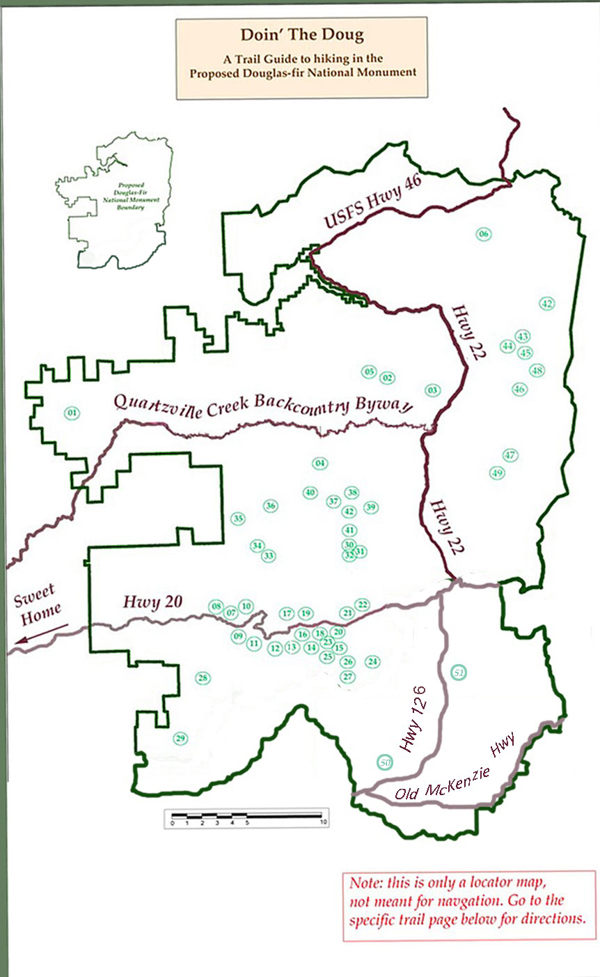
This map gives the approximate location of the trails below within the proposed Douglas-fir National Monument.
The numbers shown on the map correspond to the numbers (below) used to list the trails.

trail locator map graphic

Fire Impact.

The Lionshead and Beachie Creek fires in September 2020 and the Bruler fire in 2021 closed many trails in the area of the proposed Douglas-Fir National Monument. Many of the trails and closed roads have reopened, some are still closed. Conditions are subject to change, and the listings here may not be complete and may not reflect the conditions when you are planning a trip. Be sure to check the Willamette National Forest Alerts and Notices page.
Be careful, be sure to check for updated information on the general and any specific Willamette National forest web sites. The Friends will continue to monitor and update as they can, but the final responsibility for checking falls on you, the user.


Trail Ethics.

pack out sign graphic True friends of the wild are careful when they visit and respectful of the wild and of other visitors. The Forest Service has developed a list of Leave No Trace Principles that everyone should consider and take to heart. These principles cover not just wilderness visits, but all visits to the woods, trails and campgrounds.
hiker sign graphic Below is a partial list of Trails in the Doug, corresponding with the numbers on the map above. The links will take you to more detailed descriptions with directions to access the Trails.

Be Careful. Have Fun.

Bureau of Land Management TRAILS
01. Crabtree Valley

DETROIT RANGER DISTRICT TRAILS
02. Bachelor Mountain Trail Northern Access may be closed.
03. Bruno Meadows Trail Northern Access may be closed.
04. Bugaboo Ridge Trail Northern Access may be closed.
05. Coffin Lookout Trail
06. South Breitenbush Gorge Trail temporarily closed thumbnail graphic

SWEET HOME RANGER DISTRICT TRAILS
The District has produced its own Trail Guide PDF

Our partial list starts with the Lower Santiam Area including
07. Trout Creek Trail (into the Menagerie Wilderness)
08. Walton Ranch Interpretive Trail
09. Yukwah Nature Trail
10. Rooster Rock Trail (Menagerie Wilderness)

The Santiam Wagon Road Trail System contains several trails including
11. Mountain House to Forest Road
12. Forest Road to Seven Mile Trailhead
13. Sevenmile Trailhead to Tombstone Pass
14. Tombstone Pass to Hackleman Creek Road
15. Hackleman Creek Road to Fish Lake

There are many other trails in the same area, including:
16. House Rock Trail
17. Iron Mountain Trail
18. Tombstone Nature Trail
19. Cone Peak Trail
20. Hackleman Old-Growth Trail
21. Echo Basin Trail
22. Crescent Mountain Trail

Further south off Highway 20 are:
23. Browder Ridge Trail
24. Gate Creek Trail
25. Gordon Meadows Complex
26. Twin Buttes Trail
27. Gold Hill Trail
28. Tidbits Mountain Trail

In the northern part of the Sweet Home Ranger District you can explore:
29. South Pyramid Creek Trail
30. Pyramids Trail
31. Chimney Peak Trail
32. Chimney Peak Trail (alternative access)
33. Shedd Camp Trail
34. McQuade Creek Trail (Middle Santiam Wilderness)
35. Swamp Peak Trail (Middle Santiam Wilderness)
36. Gordan Peak Trail
37. Riggs Lake Trail
38. Daly Lake Trail
39. Scar Mountain Trail
40. North Pyramid Trail
41. Parish Lake Trail

Mt. Jefferson Wilderness area:
A special permit is required for these trails, effective May 2021. Information
42. Whitwater Trail for access to Jefferson Park temporarily closed thumbnail graphic
43. Pamelia Lake Trail
44. Grizzley Peak Trail
45. Hunts Cove Trail
46. Marion Lake and Marion Mountain Trail
47. Duffy Lake Trail
48. Lake of the Woods Trail
49. Maxwell Butte Trail

Upper McKenzie River:
50. McKenzie River National Recreation Trail
51. Clear Lake Trail


Back to the Plan your Visit Page