|
|
| HOME | PROTECTION | NATURE | PLAN YOUR VISIT | FAQ | JOIN/DONATE | ABOUT |
| DOIN' THE DOUG - TRAIL GUIDES |
|
Grizzly Peak Trail
|
| Length: 10 miles, round trip. Difficulty: Difficult 2700 feet elevation gain [WS 23] FS trail #3428: Grizzly Peak Trail A wilderness permit is required in the summer, and a special permit is required for this trail, effective May 2021. Information |
| This trail starts as the Pamelia Lake
Trail. After 2.2 miles, just before the lake, you will find a
trail junction. The trail to the right goes to Grizzly Peak. The trail climbs over 1,310 feet in the next 2.8 miles providing views of Mount Jefferson, Pamelia Lake, the Three Sisters and Three Fingered Jack. The trail ends at the summit of Grizzly Peak. 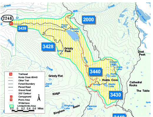
Trailhead directions: From Detroit, Oregon, travel east on Highway 22 approximately 12.5 miles to Pamelia Creek Road (Forest Road 2246). Turn left onto Forest Road 2246, travel 5 miles to end of road. Trailhead parking is on the left. |