|
|
| HOME | PROTECTION | NATURE | PLAN YOUR VISIT | FAQ | JOIN/DONATE | ABOUT |
| DOIN' THE DOUG - TRAIL GUIDES |
|
Hunts Cove Trail
|
| Length: 12.4 miles, round trip. Difficulty: Difficult 2150 feet elevation gain [WS 23] FS trail #3440: Identified by the FS as the Hunts Creek Trail A wilderness permit is required in the summer, and a special permit is required for this trail, effective May 2021. Information |
| This trail starts as the Pamelia Lake
Trail. After 2.2 miles, just before the lake, you will find a
trail junction. The trail to the left goes to the Pacific Crest
Trail. Turn right (south) on the PCT. The trail then gains 2,200
foot in elevation going south to the Pacific Crest Trail. Further
down the PCT, the trail leads back toward Pamelia Lake and along the
lake to Hunts Creek, along the Creek to Hunt's Cove. A side trail
off the PCT takes you to Hank's and Hunt's Lakes within Hunt's Cove.
There is a southern entrance, which starts from the Alternative 2 trail head. The trail climbs to the northwest and intercepts the PCT. A right turn (northwards) on the PCT and a further climb leads to Hunts Cove and the side trail to Hank's and Hunt's Lakes. This trail lends itself to a loop hike from Pamelia Lake Trailhead and is one of the most popular backpacking trips in the Mount Jefferson Wilderness. There is usually less traffic during the week. The trail offers views of Mount Jefferson, panoramic views of the western Oregon Cascades and alpine lakes. Hunts Cove is in the Pamelia Limited Entry Area, within the Mt. Jefferson Wilderness, which requires additional protection in an effort to preserve the natural beauty and wilderness experience; therefore, a limited entry quota is in effect. Under this quota, 20 groups are permitted in the area each day, only three of which may be large groups with 9 to 12 people. For these large groups, the Pamelia area is broken into three smaller areas: Pamelia Lake, Hunts Cove, and Coyote/Shale Lakes. Only one large group is allowed in each of these areas at one time. 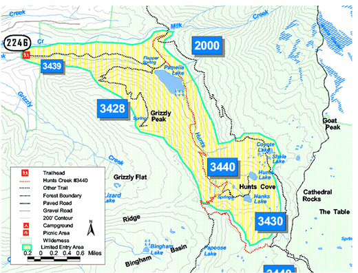 Trailhead directions: Alternative 1, Pamelia Lake: From Detroit, Oregon, travel east on Highway 22 approximately 12.5 miles to Pamelia Creek Road (Forest Road 2246). Turn left onto Forest Road 2246, travel 5 miles to end of road. Trailhead parking is on the left. Alternative 2: Access 2: From Detroit, Oregon, travel East on Highway 22 approximately 14 miles to Pamelia Creek Road (Forest Road 2246). Turn left onto Forest Road 2246, travel 5 miles to end of road. Trailhead parking is on the left. |