|
|
| HOME | PROTECTION | NATURE | PLAN YOUR VISIT | FAQ | JOIN/DONATE | ABOUT |
| DOIN' THE DOUG - TRAIL GUIDES |
|
Maxwell Butte Trail
|
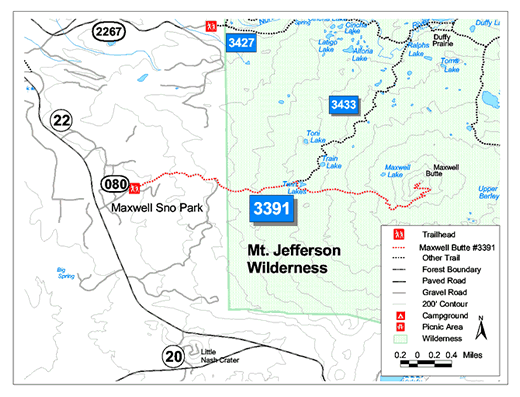
| Length: 4.6 miles Difficulty: Moderate/Difficult Elevation Gain: 3,700 - 6,230 feet Forest Service Web site (Trail #3391): Maxwell Butte Trail This trail goes into Mt. Jefferson Wilderness a summer permit is required, and, starting 2021 a special permit will be required. |
| A gradual climb through Douglas Fir, Western Hemlock,
Mountain Hemlock, true Fir forest. Trail connects with Lava Lakes
Trail #3433 near Twin Lakes. From the junction trail winds up to the
top of Maxwell Butte which has excellent views of the
Cascades. This is a popular winter ski trail as well. |

| Directions: From Detroit, Oregon, follow Highway 22 east for 31
miles to Maxwell Sno-Park parking lot, take Forest Road 080 at end
of parking lot for 1 mile to Maxwell Butte Trailhead. |