|
|
| HOME | PROTECTION | NATURE | PLAN YOUR VISIT | FAQ | JOIN/DONATE | ABOUT |
| DOIN' THE DOUG - TRAIL GUIDES |
|
Pyramids Trail
|
| Length: 1.9 miles Difficulty: Difficult Elevation Gain: 4,000 - 5,618 feet Forest Service Web site (Trail #3380): Pyramids Trail |
| This short steep trail has forests, wildflower meadows and a peak
with great views and the remains of a fire lookout. The trail ascends steep wooded slopes interspersed with broad open meadows. Near the top, rocky crags are covered with many species of alpine plants and offers spectacular spring colors. Remains of the Three Pyramids Lookout, build in 1934 lie scattered about the peak. Impressive panoramic views of the Cascades can be seen from the peak. Be Careful. This trail is part of a complex of trails that start from different trailheads to go into the area of the Pyramid peaks. This trail is the middle segment, reachable from several trails, for which the Forest Service does not provide complete maps. Segments of the North Pyramids (#4161) and South Pyramids (#3403) trails can be seen on the map below, distinguished by the trail numbers. 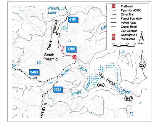
|
| Directions: From Sweet Home, travel east on Highway 20 for 41.8
miles and turn left onto forest Road 2067 (Lava Lake Road). Drive
past Road 508 (the turn to Crescent Mountain trail) for 5.7 miles
then bear left onto Forest Road 560. Continue 3.6 miles to the
trailhead, which is just past Forest Road 572. For an alternate approach, follow Highway 20 to Santiam Junction and turn left onto Highway 22. Continue 4.8 miles to Forest Road 2067 (the other end of Lava Lake Road). Turn left from Highway 22 onto Forest Road 2067. Travel 1.2 miles and turn right on spur road 560 after crossing a bridge. Continue for 3.6 miles to the trailhead on the left. Note: This is also the trailhead for the South Pyramid Creek Trail |