|
|
| HOME | PROTECTION | NATURE | PLAN YOUR VISIT | FAQ | JOIN/DONATE | ABOUT |
| DOIN' THE DOUG - TRAIL GUIDES |
|
Chimney Peak Trail
|
| Length: 12.7 miles (SHRD) Difficulty: Difficult Elevation Change: 2,300 -4,965 feet. Forest Service Trail #3382 Site: Chimney Peak NOTE: this trail goes into the Middle Santiam Wilderness (permit required). |
| Starting from the trailhead on Forest Road 2041-646
spur, the trail rapidly descends for 0.75 miles to the Middle
Santiam River. If you are not going into the wilderness, this short
hike is worth doing by itself. This segment can be seen at the Shedd
Camp Trail page. You can enjoy exploring Shedd Camp Shelter and a nearby plunge pool in the river (if you are brave – the pool is partially shaded). 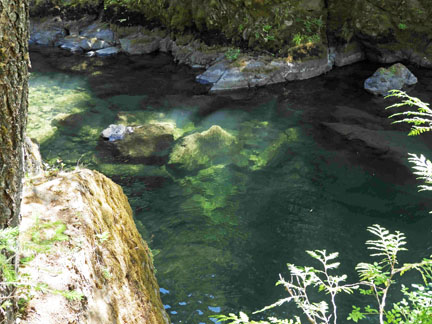
The Chimney Peak Trail continues across the Middle Santiam River (no bridge) 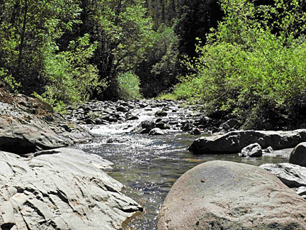
Be careful crossing the river on two counts. First of course because you are crossing a river, but also because there is no obvious trail once you get to the river, so it may be difficult picking the trail up after you cross the river. The trail continues across the river and crosses the closed Forest Road 2041 before entering the Middle Santiam Wilderness and reaching Donaca Lake. Beyond Donaca Lake, through the heart of the wilderness, the trail gradually gains elevation to the base of Chimney Peak. There used to be a fire lookout at the top of the peak. It is a challenging climb up the peak to the former lookout site. BE CAREFUL. 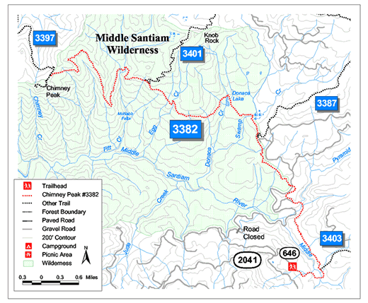
|
Directions: From Sweet Home Ranger District office in Sweet Home: travel east on Highway 20 for 23.1 miles (Highway mile 52.5) turn left on forest Road 2041 (Soda Fork Road). Stay on 2014 for 12 miles to spur road 646 and turn right. The trailhead is at the end of the spur road. The road is passable by any vehicle. There are a number of junctions, most of which are marked. If you choose the road that seems the most traveled, you should be alright. This road passes through private land as well as Forest Service land, clear cuts, recently planted sectors, and thinned middle aged second growth forests. Drive carefully, in the right season there are log trucks on the road. There is an alternative access to the trail |
Go to the Trail
Guide
Go to the Chimney Peak page in Special Places